Thomson Park to Bluffers Park
One of the rationales put forward for taking two lanes out of Brimley is to allow a cyclist to travel between Thomson Park and Buffers Park.
We’re not too sure how many people would actually make that trip, even on a nice sunny dry day, but there is an attractive alternative route which does NOT put cyclists on busy arterial roads, nor does it cross hundreds of residential driveways, not does it take lanes away from heavy industry south of Danforth Road.
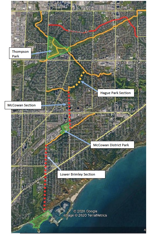
Below is an air photo of central Scarborough from Ellesmere down to the Lake Ontario shoreline.
In orange are existing multi-purpose paths separated from arterial road traffic. In red are the Brimorton bike lanes painted on the roadway.
The orange paths in the air photo run through the following parks and ravines:
- The Gatineau-Meadowway-Pan Am path systems;
- Birkdale Ravine;
- Thomson Park;
- The Highland Creek ravine system;
- The small branch of the Highland Creek that connects Knob Hill Park on the east side of Brimley with McCowan Park; and
- The 2 km diagonal path system south of Eglinton between the Bellamy GO Station and Brimley Road. It runs in the former Scarborough Expressway lands. I don’t know if it has a name so I’ll call it the Expressway Path.
To connect these with safe walking-cycling paths, there are two ‘missing links’.
- About 0.75 km through Hague park; and
- About 1.1 km south down McCowan Road from McCowan Park to the Expressway Path; ...which takes you back to Brimley south of the heavy industries.
We leave it to Councillor Crawford and his communities to decide if they want to continue a painted bike lane system on Brimley or McCowan south from the Expressway Path
McCowan Road from McCowan Park to EglintonIt’s a dead end. It operates as a local street carrying very little traffic compared to an arterial like Brimley.
No TTC buses operate on this part of McCowan.
There are only 2 homes with driveway to this part of McCowan.
It is paved today as a two-lane street but the City owns a 27m wide right of way. There should be lots of room to build a separate cycle track down to Eglinton.
McCowan south from Eglinton
It’s four lanes and in my experience, this part of McCowan is not heavily travelled. If there is no feasible way to build a bike path separate from the travelled lanes under the CNR-GO line here, the impact on traffic of taking two lanes should be far less than taking two lanes out of 4 kilometres of Brimley.
The Bellamy 9 TTC bus runs on McCowan south of Eglinton. The latest data available to us shows that this bus carries less than half the passengers that ride the Brimley 21 bus every day.
If you believe a lot of people want to ride bicycles down and back up the severe slope of Brimley below Kingston Road and you think that slope is safe for all ages/stages of cyclists, then proceed with that part of your plan.
Advantages of our Hague Park-McCowan Road proposal:
- Builds on/ connects to the existing Highland Creek and Expressway path system;
- Displaces very little traffic from busy arterial roads;
- Does not interfere with busy TTC bus routes;
- No conflict with heavy truck traffic from industrial operations;
- Crosses 2 residential driveways from Thomson Park south to McCowan District Park and back to Brimley south of Skagway.
- Puts more people on the Expressway path which increases safety for everyone.
- Connects to McCowan District Park:
- Scarborough’s only outdoor skating trail
- Scarborough’s second outdoor skating rink
- Sports fields
- Splash pads
- Children’s play areas
- Picnic areas


Below is how it lays out. Red lines are existing bike lanes painted on roads. Orange lines are existing pedestrian-cycle paths in Scarborough parks and ravines.
Lorne Ross for Glen Andrew Community Association
My apology for mis-spelling Thomson Park. Lorne
ReplyDelete